|
|
Autumn’s Ill Winds
by Dick Wilson
When we hear that a hurricane is chugging up the East Coast from the Caribbean, we can thank God that we are not among those unfortunates who get hit frequently by the full force of monstrous storms.
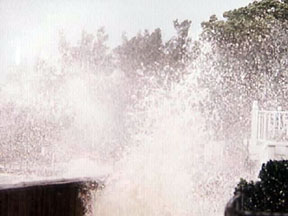 |
photo by Bruce Wahl
Although an ‘indirect hit’ by hurricane standards, 1995’s Hurricane Fran pounded Chesapeake Country with damaging winds and waves. Above, spray breaks over the Atlantic Avenue boardwalk in Chesapeake Beach. Waves from Fran chewed up the boardwalk. |
Guam, July 5, 2002–This is high drama. I sit in my hotel room, mulling over what kind of weird fate has managed to put me on the island of Guam at this time, in the midst of a hurricane — or more precisely, a typhoon. The western Pacific, where Guam is, doesn’t produce hurricanes, only typhoons. But don’t think you’re missing anything: Typhoons and hurricanes are the same animal. They just do their jobs in different parts of the world. And in this part of the world, I was experiencing Typhoon Chataan, the most damaging typhoon to hit Guam since 1998.
Back at the hotel, the rain is coming down in sheets, and the wind outside is roaring so loudly that my wife and I can barely hear ourselves speak. We watch through the window (on Guam windows are built to be typhoon-proof, and that’s nice) as the 110mph winds (gusts to 150 mph) tear at the tall palm trees, bending them almost horizontal. Many of the palms become topless as their fronds are ripped off and whisked away. Large, dark unidentifiable objects fly by. Then we see nothing, because at times the rain becomes so heavy that visibility drops to a few feet. I wish I were back home on the shores of the beautiful Chesapeake Bay, where we don’t (or we’re not supposed to) have outrageous hurricanes and typhoons.
On the Shores of our Beautiful Bay
Gentle breezes and mild, crisp days. That’s Chesapeake Bay in late September. Having escaped unscathed by Typhoon Chataan (hey, I’m not responsible for naming these things), we are out of typhoon country and back home in Chesapeake Beach, which is, they tell me, part of hurricane country. But all is not calm; a blustery future waits for someone, somewhere, as Tropical Storm Isidore builds down around Cuba, threatening to become a hurricane.
North America is more than halfway through the 2002 Atlantic hurricane season, which The National Oceanic and Atmospheric Administration defines as June 1 through November 30 — as though “the season” is going to consist of events that require preplanning, as if we need to get our tickets early.
Every year, we’re warned to be prepared for the coming hurricane season and told to count our blessings because no hurricanes have hit us lately. How many major hurricanes have hit Maryland since 1900?
The answer: None. That’s right: zero, zilch, nada. According to NOAA, Maryland has never received a direct hit from a major hurricane (note the stress on the word major).
Big Winds
Now for the disclaimers:
First, tropical storms and hurricanes both start in the tropics. A storm with maximum winds of 73mph or less is a tropical storm; a storm with maximum winds of 74mph or more is a typhoon in the Pacific or a hurricane over the Atlantic.
Second, a “major” hurricane is one that is rated 3 or higher on the Saffir/Simpson Scale. Yes, we’re playing a name game here. The highest rating a hurricane can receive on this scale is 5 (wind velocity greater than 155mph and catastrophic damage). The lowest is 1 (less than 95mph and minimal damage). A Category 3 hurricane has maximum winds of 111 to 134mph, but a “minor” hurricane (Category 2) with winds of 110mph can still inflict a lot of harm.
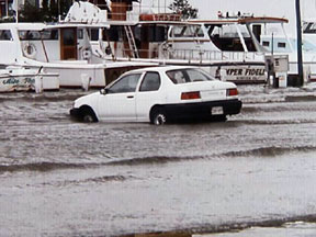 |
photo by Bruce Wahl
Waves from Hurricane Fran brought car and boats together. |
Third, when NOAA reports a “direct hit” on an area, it means that the area experienced the maximum wind velocity measured within the storm. The part of the storm called the “eye wall” is the place where the winds are strongest. The eye itself is relatively calm, with a diameter usually on the order of 25 miles or so. Wrapped around the eye, however, is the eye wall. The farther from the eye wall, the less the wind velocity, so a Category 5 storm — winds greater than 155mph in the eye wall — may cause little damage at, say, 100 miles from the eye.
Fourth, it is impossible to measure wind velocity everywhere all the time, so a thunderstorm generating measured wind velocity of 40mph may have cells within that reach 100mph. The only way we know that is by what happens, for example, when the boats in a marina get tossed onto dry land. All storm systems can generate high winds that can be very brief and very localized.
Finally, our part of the Bay is a fair distance inland. For complex reasons, the eyes of most hurricanes and tropical storms remain over the ocean. So if we are brushed, it is almost always by the western side of the storm, the area that is usually the least violent. If a hurricane does proceed inland, it usually dissipates rapidly, becoming your good ol’ everyday rainstorm.
The point is that high winds can be harmful, as we all know, regardless of storm nomenclature.
A Wind’s Worse Than a Word
When we hear that a hurricane is chugging up the East Coast from the Caribbean, we in Maryland can expect to see a fairly common show, gusty winds and rain, and we can thank God that we are here on our Bay and not among those unfortunates — usually in the Carolinas and points south — who get hit frequently by the full force of monstrous storms.
Maryland has been brushed (i.e., was indirectly hit) by “minor” hurricanes at least 26 times in the past 132 years, and a couple of the most recent were real troublemakers. In 1955, Hurricane Carrie resulted in the loss of 14 lives when a schooner, the Levin J. Marvel, foundered in Herring Bay [Reflection: Vol. X No. 32, Aug. 8]. In 1996, Fran caused extensive beach erosion and property damage in the Twin Beach area.
Most, however, just raised the tension level and kept the watermen ashore as they came and went. In addition, many tropical storms have passed by and caused more damage than some hurricanes. And hardly a year passes that parts of the D.C./Maryland area are not seriously damaged by high winds from common thunderstorms.
Sitting on Guam, watching Chataan amble by, I mused that wind is wind, and it doesn’t much matter what kind of storm it comes from — just as you don’t really care if the windstorm that ripped the roof off your house came from a hurricane or a typhoon like Chataan or a local summertime thunderstorm. What matters is that your roof is gone. That’s drama enough.

Hold the Wind, But Pass the Rain
No high double-digit winds — not to mention triple-digit winds — are needed in Chesapeake Country. But our enduring drought has provoked water-watchers to think wistfully (even wishfully) of the heavy rains that hang around the edges of hurricanes.
Filling our wells and reservoirs would take 12 inches of rain, according to the Palmer Drought Index. Can Tropical Storm Isidore — or any other big blow — bring that much water to Chesapeake Country?
In 1999, Hurricane Floyd wiped out the rain deficit along much of the East Coast.
So, says the Climate Prediction Center of the National Oceanic and Atmospheric Administration, “one storm can make a difference.”
But in endurance, drought might win out. Our “seasonal precipitation outlook” is so bad, reports the Center, that “even with tropical rains bringing improvement in September, this region could see a return to dry conditions by December if the expected dry pattern returns.”
— Bay Weekly
Copyright 2002
Bay Weekly
|