 |
||||||
|
||||||
|
||||||
St. Mary’s River and CitySeclusion, History and SailingLatitude 38.11 N; Longitude 76.25 WAs Virginia and the nation celebrate the 400th anniversary of the founding of the Jamestown colony, many Bay cruisers are heading south to tour these sites. There are many good gunkholes and interesting places to visit in the southern part of the Chesapeake along the way. One of them is St. Mary’s City on the river of the same name, a tributary of the Potomac. It’s the site of the fourth permanent British settlement in North America, whose first residents arrived in 1634 aboard the ships Ark and Dove.
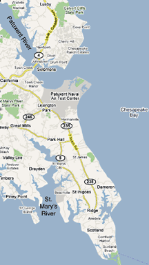
When a City Is Not a CitySt. Mary’s City doesn’t actually exist, at least not as we would think of it. But you will find there a fascinating and extensive historical park, with living history programs and ongoing building reconstruction and archaeological digs. A replica of the square-rigged Dove at its own special wharf is also part of the living history program. St. Mary’s City was the site of Maryland’s first capital. The 1676 Statehouse has been rebuilt as well as Smith’s Ordinary, and the Godiah Spray Plantation operates as a working colonial farm. The rebuilding of the 1667 Brick Chapel, important in the fight for religious tolerance, is in progress as well as rebuilding of the Print House of the same period. There are tours, a museum shop and many special events for adults and children, which also makes this a great stop for a cruising family. For boat racing fans, St. Mary’s is important as the destination for the annual Maryland Governor’s Cup Race the first weekend in August. Adjacent St. Mary’s College also has an active sailing and racing program, and the campus offers a beautiful view of the river and its activities. Getting There and AnchorageTo reach St. Mary’s River, consult your chart and locate the Potomac River (Maryland Cruising Guide Chart 14). Use caution if you haven’t been in this area before: Wind and currents can be intense, so it’s wise to stay well offshore and be very mindful of the helm. This is not an area for autopilot. Point Lookout, the southern tip of Maryland, marks the northern entrance to the Potomac. Marker GC (green can) 9A is located on the western side of the Bay off the tip of this point. From there a course of about 250 degrees takes you to marker RW A, a whistling buoy. Change to a course of about 321 degrees and proceed upriver to the Red-Green SM (St. Mary’s) marker, a distance of about 5.6 miles. You will be directly south of the river entrance. Change to a course of about 355 degrees, and travel into the river. There is plenty of depth and the river is wide. Keep to midstream. Pass the Green 1, which will be to port, and continue upriver past the Red 2, to starboard. The river makes a bend to the northeast, and you will see the mouth of St. Inigoes Creek. Across the river is the Green 3 marker on the western side of the channel, designating the entrance to Cartagena Creek. Proceed up the river, which bends back somewhat to the northwest. There are no further markers between here and St. Mary’s City, but you will see it to starboard another couple of miles up. The buildings on the bluff and the replica of the Dove at its dock below are the beacons of arrival. There are no marinas at St. Mary’s City, but you can anchor in the river below or above the town. Your chart should show Horseshoe Bend, a large crescent in the river just past the point where St. Mary’s sits. The college docks are there, and if it’s not crowded, you can anchor in the northern part of the bend away from these docks. However, stay well clear of the waters around the college because their sailing teams use the area daily. We opted to round the point to the west of the bend and dropped our hook in the small dip on the southern shore, (or the northern shore of Pagan Point), which proceeds out from the west shore of the river across from St. Mary’s. This was a pleasant anchorage with little traffic. From this location, or anyplace on the river nearby, you can dingy to the college dock and tie up to go ashore. If you are lucky, as we happened to be, you may find room to dock your boat and not have to use your dinghy. In either case, it’s a lovely walk from the docks up the hill through the college campus to the historical park. There are signs and friendly people everywhere to help you. Coming or Going, a Great Place to VisitWhether coming or going on your southern cruise, St. Mary’s City is a wonderful place to go ashore. However, it is not a place for provisioning, and there is no commercial marina. Dennis Point Marina, located in Cartagena Creek, is the nearest place for marine supplies and facilities. Depending on your draft, you could also anchor in this creek or in St. Inigoes and have only a few miles to travel to reach St. Mary’s City. If you want to include St. Mary’s in your travel itinerary, go to its website for details on hours of operation, special events and other helpful information: www.stmaryscity.org. |
||||||
|
|
||||||
|
© COPYRIGHT 2004 by New Bay Enterprises, Inc. All rights reserved. |
||||||