Along the quiet shores of Battle Creek, a determined research team regroups to search for remnants of the 17th century town of Calverton. Calverton, aka Battle Town or Calvert Towne, is among the earliest settlements in Calvert County.
Typically, “these sites hide,” says state terrestrial archeologist Dr. Charles Hall of our early settlements. “Only a fraction of the approximately 13,000 archeological sites in Maryland have been inventoried.”
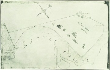
Calverton is the rare site that is found rather than lost. It was documented in a 1682 survey plat to help two colonial settlers, William Barry and Michael Taney, settle a land dispute. The plat, which was used to determine the town boundaries, was rediscovered in the Maryland State Archives in the late 20th century.
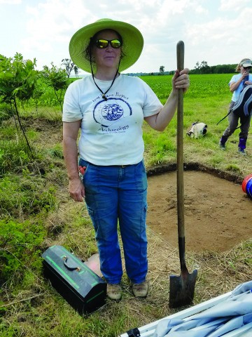
For 11 days last year, the field team surveyed the old settlement by land and water. Working alongside professional archeologists, visitors joined in the annual public event of the Archeological Society of Maryland (www.marylandarcheology.org). The team returns to Calverton this month and next (see sidebar for details).
The field sessions are always great fun because people “work with others in common purpose and common enjoyment,” said Calvert County’s Preservation Planner Kirsti Uunila, primary investigator of the dig.
Old-Time Tools
Armed with modest kits of shovels, trowels, brushes, sieves and plastic bags, terrestrial archeologists searched the earth’s surface for traces of early Marylanders. The site of the first county seat and the second town in the Maryland colony, Calverton is “arguably the most important historic archaeological site we have in Calvert,” Uunila said.
Important has a special meaning for archaeologists. “All sites are not created equal,” Hall explains. “An important site teaches us something we didn’t already know about the past.”
The Battle Creek site of Calverton meets that criterion, he said, “widening our understanding of life in colonial and pre-colonial times.”
The field session is important as well, widening our understanding by, Uunila says, “undeniably establishing the site of the town.” Earlier researchers identified features such as a kitchen site and a shell midden. Last summer’s five-acre dig confirmed many of the sites on the 1682 plat.
The Calverton site has maintained its integrity over the centuries, little disturbed by construction or development. Uunila attributes that to the stewardship of the property owners, most recently Don and Jean McDougall. The McDougalls have been “generous and accommodating,” allowing the team of 50 archeologists and volunteers access, Uunila said.
A Modern Image of the Past
Imagine that, like the McDougalls, you could walk this historic site, following the same path as people more than three centuries earlier. The 1682 plat offers a hint of what once was, but more recent imaging technology created the pathway to the Calverton site.
“The way we used tech was cool,” Uunila said. The researchers took the Google Maps app to a higher level by using the GIS program to overlay the 17th century on the present site. Most landmarks on the plat lined up perfectly. The 1682 map was “very impressive in its accuracy,” Hall said.
Researchers traced burn patterns from 300-year-old firepits and hearths hidden beneath the surface using a magnetic susceptibility test. The images — laid out in a grid pattern — are easy to read and interpret, not unlike an old photographic negative.
A bird’s-eye view of the Calverton site gives another perspective. After more than a dozen test units were opened and explored, volunteers Steve Lenik of St. Mary’s College of Maryland and Isaac Shearns of Baltimore flew a drone over the site. Very high-resolution photographs of the site were stitched together and referenced back to map coordinates for accuracy.
The final pieces of the puzzle lie beneath the surface of Battle Creek.
Diving into History
Water has always attracted human habitation, and the early settlements of the Maryland colonies were no exception. Eight of the 10 structures on the 1682 map were oriented toward Battle Creek, with several now underwater.
Underwater archeologists used magnetic susceptibility testing, bathymetry and side-scan sonar to create an image of the historic Calverton shoreline that featured a bank, a small beach and a clean drop-off that suggested the edge of a former shoreline that related to the 1682 map. The 1682 shoreline was 120 to 150 feet offshore from today’s Battle Creek shoreline.
Maryland’s archeological resources are undergoing a “full frontal assault” from accelerated erosion and sea level rise, Hall said.
For example, approximately 10 feet eroded from the Calverton shoreline since 1994, Uunila estimated. Hurricane Sandy in 2012 was responsible for about five feet of that loss.
“Archeology takes time,” Uunila says. Facing threats from human development and Mother Nature, time could run out for Calverton and many of our waterfront archeological sites.
Dig In!
Upcoming Public Archeology Events
Thursday, May 17
Lost Towns Project: Basic Lab Procedures. 6-9pm, Historic London Town and Gardens, 839 Londontown Rd., Edgewater. rsvp: [email protected]
May 25-June 4
Tyler Bastian Field Session in Maryland Archeology, 8:30am-4pm, Calverton Site, at Battle Creek, Calvert County. rsvp: [email protected]
Saturday, May 26
Spenser O. Geasey Memorial Lecture with assistant state underwater archeologist Troy Nowak. 7pm, Harriet Elizabeth Brown Community Center, Dares Beach Rd., Prince Frederick: [email protected]
Thursday, June 7
Lost Towns Project: Historic Ceramics Identification. 6-9pm, Historic London Town and Gardens, 839 Londontown Rd., Edgewater. rsvp: [email protected]
June 20-23 & 27-30
The Lost Towns Project Field Sessions in Archaeology. Join archaeologists to investigate the 18th century home of Alexander Ferguson, a merchant, tailor and prominent resident of the colonial seaport of London Town. No archaeological experience required. $20 or $55 for each 4-day field session: www.losttownsproject.org/ferguson-field-session.
Tours at 10:30am and 1pm. Historic London Town and Gardens Visitor Center, Edgewater: $3.