by Connie Darago with Christy Grimes and M.L. Faunce
Many of ChesapeakeCountry’s old guiding lights are facing rough seas. In these dark days of winter, Bay Weekly reports how 10 lighthouses in the mid-Bay are faring.
Lighthouses, those beacons of safe harbor that have lit the way of many a mariner since the early 1800s, couldn’t be more popular. They flourish in miniature on mantles and mirrors, puzzles, pillows and paint-by-numbers. But for all their miniature popularity, many of our old guiding lights now face rough seas. Their numbers are diminishing and condition declining.
Over 100 cottage, tower and screwpile lighthouses were erected between 1791 and 1910 to mark the dangerous waters of some 70 sites on Chesapeake Bay.
Moving ice and shifting sands unseated some of those lighthouses before the 20th century decommissioned them all. First, automation phased out the keepers. Then, satellites made the lighthouses themselves obsolete. Now under three dozen remain. Some are intact, some moved and others restored. The rest endure in various stages of decay.
Their predicament is not for lack of love or interest. Aficionados can tick off lights they’ve visited and photographed like a mother calling names in a big, loving family. But saving a lighthouse takes opportunity, dedication and long-term commitment — plus the will to break through miles of red tape.
In these dark days of winter, Bay Weekly takes a look at 10 lights in the mid-Chesapeake — roughly from Annapolis to Point Lookout in St. Mary’s County — to see how these Bay icons are faring these days.
Sandy Point (#1)
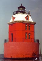 photo by Andi Blasi photo by Andi Blasi
Ah, the wages of automation: it’s cheaper without a keeper, but with no hands on deck, lighthouses fall apart or fall to vandals. That’s just what happened to stately Sandy Point Shoal Light 20 years ago. A baseball bat-wielding fiend either paddled or swam to the house and smashed the light’s finest treasure: its 19th century handmade crystal lens. Let it be said, this seaworthy vandal showed pep and initiative, since Sandy Point Shoal Light stands in 13 feet of water 3,000 feet from shore, beyond the easternmost point of the Broadneck peninsula.
The replacement acrylic lens can’t match the glory of its original, but Sandy Point Shoal Light still flashes splendor to spare. Described as “one of the prettier caisson lighthouses built on the Bay” by Lighting the Bay author Pat Vojtech, Sandy Point’s octagonal brick dwelling is a feast of Victorian gingerbread. The original two-tone diamond shingles have been replaced by prosaic white squares, but gabled dormer windows still poke through the mansard roof of its watch level. Caretakers have obscured the decorative brickwork with a heavy coat of red weather paint, but the molded-brick window ornamentation shows through.
Built in 1883, this house is actually the second station at Sandy Point. The first was a big bomb. Launched in 1858, its feeble fifth-order Fresnel lens, together with its unfortunate placement far inside the shoal it was supposed to mark, made it invisible to most boaters. As steamer traffic grew, so did gripes. The Lighthouse Board asked for a new one with a bigger light in a better spot. By the time the board got the $25,000 they needed, it wasn’t enough for the tried-and-true screwpile they pictured. They more than made up for the disappointment by erecting the frilliest tower caisson on the Bay.
Between 1988 and 1990 the Coast Guard gave Sandy Point Shoal Light some TLC, repainting the house and restoring some of its frou-frou, but there is still almost a million dollars-worth of work left to do, according to Maryland Historical Trust: structural reinforcement, replacement of crumbling bricks and woodwork refinishing are just a few of the needed repairs.
Though it can’t be reached (legally), this Bay beauty is easy to ogle. Glance to the right as you head west over the Bay bridge. Or visit the beach at Sandy Point State Park.
Thomas Point (#2)
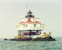 photo by Andi Blasi photo by Andi Blasi
A few years ago, a family motored out from the South River to sprinkle their father’s ashes over Bay waters near Thomas Point Light. That act is illegal in Maryland, but a more fitting resting place eluded the family, who remembered their father at his happiest when trolling for fish near the sacred spot he had loved since a boy summering in Edgewater Beach.
Thomas Point Light has been a familiar backdrop for fishing trips and Bay boating for generations of local families. The Coast Guard learned just how much an icon the old screwpile lighthouse was in 1975, when the public protested a proposal to tear it down. Today, the treasured structure — set near the mouth of the South River a mile out in the Bay from Thomas Point and visible by land and sea — is listed on the National Register of Historic Places. In 1995, the light was designated a National Historic Landmark, only one of six in the country so honored.
The first Thomas Point Light was built in 1825 on land on a 30-foot high clay bank. After years of erosion — a story of time and tide and the Bay itself — the old house was decommissioned. In 1875, the light we know today was screwed into the Bay bottom a mile offshore. The familiar rubble of rip rap was added in 1886 to protect the building from the ravages of ice.
It all worked. In excellent condition, Thomas Point is the only intact cottage-style screw pile lighthouse in the country that remains in its original in-water location. When it was automated in 1986, the beloved light was the last manned screwpile lighthouse on the Chesapeake. Its white sector light can be seen for 13 miles, the red sector for 11 miles, as Thomas Point continues to light the way to the middle Bay.
Bloody Point (#3)
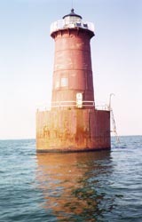 photo by Andi Blasi photo by Andi Blasi
“You learn to sleep four hours at a time,” Bloody Point keeper Tom White told the Baltimore Sun in 1948. “It’s a little hard when the horn is sounding off, but you get used to it.”
Known to locals as the “Coffee Pot” for its shape, this cast-iron caisson lighthouse was probably none too comfy even without its foghorn, which still blasts every 30 seconds day and night, rain or shine.
In 1960 it got downright uncomfortable for the two coastguardmen succeeding White when an electrical fire swept through their quarters, forcing the pair to make off in a motorboat moments before the red-hot Coffee Pot’s fuel tank exploded. “It became a tower of flame,” recalled one of the guards, 19-year-old Mark Mighall, who watched in horror from the safety of their retreating boat. “It was awful watching your station burn.”
After the fire, only the cast-iron shell of the lighthouse remained. Its lens and light had dropped into the burning interior. The catastrophe ushered Bloody Point into the Age of Automation: with a new lens and light, the station started unmanned operation the same year.
Seeing Bloody Point Light by land is tricky for even the most determined lighthouse maven. It sits on Bloody Point Bar off the southern tip of Kent Island, where the shoreline is privately owned. After driving the length of the island, you’ll have to make a few friends to get a good look at this 56-foot coffee pot, percolating since 1882.
The light was actually planned back in 1868 to mark the dangerous sandbar named Boody Point. Usual red-tape delayed building until 1881.
Soon after it was lit in 1882, the house began to lean. Tipping five degrees over, the Coffee Pot almost rivaled its cast-iron caisson cousin, Sharp’s Point Light, for Leaning Tower of Pisa twin. Determined workers pushed it back up and dumped an entire 760 tons of rock around the base to keep sand from washing away again. The tower still leans, but ever so slightly.
In 1988, several years past its 100th birthday, the U.S. Coast Guard gave the cracked and rusting lighthouse a modest makeover. Once a cross between blood red and coffee brown, the shell was repainted a tasteful shade of bone. Though needing deeper repair to keep it standing, the hardy Bloody Point Light still blinks and blows its horn to prevent bloodshed, bone breaks and all other maritime mishaps.
Hooper Strait (#4)
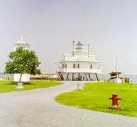 photo by Connie Darago photo by Connie Darago
“Last year we had over 90,000 visitors, and most of them toured Hooper Strait Lighthouse,” says Deborah Divins of Chesapeake Bay Maritime Museum.
Nowadays you don’t find Hooper Strait Lighthouse at Hooper Strait in Tangier Sound. Instead, you look to St. Michaels.
It’s a pleasant drive that takes you back in time as you enter the Currier and Ives picture-postcard town. There, in the middle of brick-paved streets, you find the Chesapeake Bay Maritime Museum, home of the Hooper Strait Lighthouse since 1966.
The restored three-story cottage style house with green roof, dormers and shutters stands majestically by the water’s edge on its new foundation. A flight of steps takes you up to the 1910-era house.
Hooper Strait is one of only three remaining screwpile structures once more than 40 strong that lit the way in Chesapeake Bay. It’s authentic, but it’s not original.
It descends from an 1867 original, constructed on the north side of the entrance into Tangier Sound to mark the shipping channel. That screwpile lighthouse stood for only 10 years when it succumbed to moving ice. The lighthouse was found five miles south of the Strait sunk in water to its roof line. The lens and bell were salvaged, and the keeper and assistant rescued.
In 1879, Congress approved $20,000 for a replacement in the same style, once more to be mounted on steel screwed to caissons laid on the Bay bottom. This cottage-style lighthouse was built at the Lazaretto Depot in Baltimore, dismantled and shipped by schooner to Tangier Sound.
Owned by the U. S. Coast Guard, the station was fully automated in 1954, when keepers were abandoned. But by 1958, all screwpile dwellings were ordered removed from Chesapeake Bay. Most cottages were burned. The skeletal structures remaining had lights mounted to show the way.
The lighthouse would have been burned had not Chesapeake Bay Maritime Museum cut through heaps of red tape to buy it. The cottage, cut in half just below the eaves, was moved by crane and tug 40 miles north to St. Michaels without cracking a single pane of glass: a good job for $26,500.
Now the lighthouse draws nearly 100,000 visitors each year. Reviving the old tradition, some sleep over on summer’s nights and take a turn being keeper for an hour.
Far north of its original home, Hooper Strait shines on — another lighthouse saved from darkness.
Sharps Island (#5)
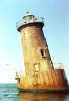 photo by Andi Blasi photo by Andi Blasi
Sharp’s Island Light once dominated one of the largest island’s in Chesapeake Bay. The 700-acre island washed away slowly, disappearing altogether in the 1940s. Memories linger of the last speck of land that anchored the light. Alice Bradshaw of Annapolis accepted a marriage proposal at the lighthouse. Edwina Murphy of Tilghman remembers rowing out to the lighthouse with the keeper’s children to spend the night. “There were bunks lining the walls,” she said of the diminutive living space.
The light is now awash in10 feet of water and listing at a 15-degree angle that makes it Maryland’s answer to the Leaning Tower of Pisa. Were it upright, the leaning 54-foot brown tower would be the twin of Bloody Point Light.
For reasons no one seems to know, Sharps Island Light lighthouse was first painted purple. About three years ago, it was repainted the reddish brown so familiar to boaters and fishermen. The new paint job and maintenance work followed, Lesher says, “widespread public resistance” when the Coast Guard announced plans to “tear it down.”
With Coast Guard funding to spruce up the lighthouse, the crisis is forestalled for the next few years.
A light has shone over the shoals off Black Walnut Point near the entrance of the Choptank River at the end of Tilghman Island since 1882. But this is the third Sharps Island Light.
The first constructed in 1837 was moved inland after the island lost half of its acreage. In 1866 a new screwpile lighthouse was built, only to be swept away by ice in 1881.
Ice struck again in the 1970s, causing the familiar lean that is so welcome a sight for boaters, who say its distinctive presence makes it as reliable a navigation aid by day as night.
Cove Point (#6)
 photo by Connie Darago photo by Connie Darago
“We are reasonably hopeful that the lighthouse property will be leased to us in the year 2000,” reports Calvert Marine Museum’s Richard Dodds. “The legal draft is complete. We’re not sure now what the problem is.”
The problem is that the lighthouse was supposed to be leased to the museum by the Coast Guard at a bargain price. Instead, it’s tangled in red tape.
You can approach this on-shore tower by driving Rt. 2/4 to Cove Point Road, then winding through the small summer cottage homes to the road’s end and the surprise of the magnificent Cove Point Lighthouse. But you can’t come in except in the Museum’s annual festival of Winter Lights. Someday, perhaps, Cove Point will be as accessible as Drum Point.
But for now, the 38-foot truncated tower and keeper’s house stands stately behind a high-locked chain link fence. The same barriers that keep most visitors out plus 150 years of regular maintenance have perfectly preserved the lighthouse.
With an azure blue sky and the Bay as its background, the white painted structures cast a glare as sunlight engulfs them.
The cozy 34-by-30-foot dwelling, built of local brick by John Donohoo, followed the same floor plan Donohoo used in his other Chesapeake lighthouse keeper’s homes. All were eventually enlarged, and a second story was added to Cove Point in 1883.
Peeking through the neatly caulked windows, you’ll see a home ready for occupancy as it was when James Somervile became its first keeper in 1828. The winding tower stairs are unique wooden treads, triangular with a hole through which a central wooden column is threaded. The outside of each tread is mortared directly into the masonry wall.
Viewing the tower’s smoothly worn stairs, you can imagine the thousands of trips keepers must have made up and down to work the fourth-order Frensel light.
Tower and home have stood a long time. In 1828, Congress approved $5,685 for construction of a lighthouse at Cove Point, four miles north of the entrance to the Patuxent River, to mark the shoal that extends outwards toward the shipping channel.
In 1986, electronics overrode the manual system, and now a fog detector is automatically activated when visibility drops below three miles. Today the light is maintained by a computer connected to the Coast Guard headquarters in Baltimore. But the original lens still works, resting atop a glass and brass box housing the winding mechanism that once rotated the light to create the flashing effect.
Cove Point Lighthouse, still shining the way, is well worth the venture off the beaten path. Who knows? On a foggy day, you may be lucky enough to see a real lighthouse at work.
Drum Point (#7)
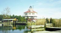 photo by Connie Darago photo by Connie Darago
“We had over 60,000 visitors at the museum last year, and the Drum Point lighthouse is the reason many came,” said Richard Dodds of Calvert Marine Museum’s most famous lighthouse.
The gem of Calvert Marine Museum is in mint condition today at Solomons, not Drum Point, thanks to donations from the National Park Service, Maryland Historical Trust, the Calvert County government and private donors.
Last October the interior of the story-and-a-half cottage was restored to the 1909-1911 period. Historical paint consultant Matthew Mosca matched the original paint shades for the restoration by analyzing paint samples. Pine floors were sanded and sealed to complete the period look.
Restorers could have chosen an earlier date. Plans for Drum Point Lighthouse date to 1853, when $5,000 was allocated for building a lighthouse on the north entrance to the Patuxent River to help mariners navigate the entrance to the Patuxent River and avoid the dangerous shoal water off Sandy Point Bar. Red tape delayed building for 30 years.
Finally, in 1883 the screwpile cottage rose in 10 feet of water. Eighty years later, shifting sands landlocked the lighthouse.
Back then, nothing much was unusual about the gem of the Marine Museum.
“The lighthouse was an off-the-shelf design,” says Dodds. “Its ironwork was fabricated in Allentown Rolling Mills of Philadelphia, PA, assembled at Dupont Lighthouse Depot in Baltimore, then shipped to its site for assembly.”
Service was discontinued at Drum Point in 1962. But in 1966, the Calvert County Historical Society rescued the lighthouse. Red tape blocked transfer of the title until 1974.
Mother Nature had placed the lighthouse on solid ground by then, and vandalism, neglect and bureaucratic snarls nearly did in the abandoned structure.
Eventually, the 41-ton cottage was moved two miles inland to Backwater Creek near the Calvert Marine Museum.
Later this year, wood railing and some walkways will be replaced, using donations and grants.
Its light was often darkened during World War II when the area was used for training maneuvers, but Drum Point Lighthouse shines through war and neglect to light up the day for its thousands of yearly visitors.
Cedar Point (#8)
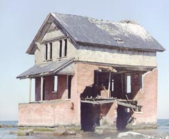 photo courtesy of the Calvert Marine Museum photo courtesy of the Calvert Marine Museum
In 1996, hopes were high that Cedar Point would join Calvert Marine Museum’s family of lights.
The Navy, its owner since 1958, begged historical groups to give the lighthouse a home. But Cedar Point lighthouse proved too decrepit to save.
The best that could be done was to hoist the wooden third story onto a barge and tow it to the museum. There it was dismantled, and what could be, preserved: bricks, architectural details, the sunburst gable ornaments, beams, shingles and slates.
In 1981, the bell was removed to the entrance to the Patuxent Naval Air Station, where you can see it today.
A century earlier, in 1896, the Light House Board had requested $25,000 from Congress to build Cedar Point lighthouse on the southern side at the mouth of the Patuxent River to mark a dangerous sand bar. Unusual among lighthouses, it was a three-story brick and cedar-shingle house crowned by a 50-foot tower housing lens and fog bell.
But Cedar Point quickly eroded, hastened by local sand dredging. By 1920, when the lighthouse was abandoned, it stood on an island — apparently forgotten.
Now, nature is taking its course. Soon Cedar Point will cross the bar.
Point Lookout (#9)
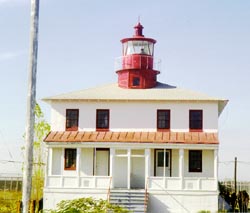 photo by Connie Darago photo by Connie Darago
“My brother and sister-in-law lived in the lighthouse and I enjoyed spending time there,” says Donnie Hammett, grounds keeper at Point Lookout State Park.
To reach the park and lighthouse, which stands at the end of St. Mary’s County where the Potomac River meets the Bay, you travel Rt. 5 south past tobacco fields, horse-pulled Amish buggies and towns with mom-and-pop groceries.
Hammett reports lighthouse problems to the U. S. Navy, its owner. What the Navy does about those problems falls far short of what’s needed.
“They removed raccoons that were ransacking the house and did storm damage repair to the cupola last fall. The house is in bad condition, but there are no current plans for restoration,” says Hammett.
The lighthouse has been spiraling down hill since 1980 when the state relinquished its lease rather than repair failing systems.
Wood-paned windows are rotten with little paint left to ward away harsh weather. Interior walls have large gaping holes exposing the original dull-red brick.
It’s bad enough that — should you arrive on the first Saturday of November, the only public access day — you wonder if it’s safe to tour.
The crumbling structure is a far cry from its beginning.
Point Lookout Light came into being in 1828, when Congress approved $4,500 for a small beacon light to mark the north entrance to the Potomac River.
John Donohoo, the nation’s finest early lighthouse builder — contractor of 13 stations on the Bay and 31 in his career — was commissioned to build the diminutive white house with its red roof and black lantern.
Point Lookout lighted the way for 12 miles in a peaceful era. When the Civil War engulfed the nation, 36 years after its founding, it added a new role, monitoring ships entering the Potomac.
At the Point, a federal prisoner of war camp and a hospital were constructed. Nearly 4,000 Confederate soldiers and 500 Union guards died during 16 months, to be buried near the lighthouse. Gravesites were exposed as waters pounded the sandy graveyard, leaving an eerie haunting.
The pain of these years lives on, as almost everyone who has spent time in the house tells stories of ghostly sounds and apparitions. It is the only Chesapeake Bay lighthouse that has been investigated for paranormal phenomenon for psychologists.
At present, its future remains uncertain, but the structure is losing ground fast.
Your recompense for driving to Point Lookout is a chilling glimpse of the Civil War as well as a look at a lighthouse whose future may be as dark as the war that once raged around it.
Piney Point (#10)
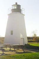 photo by Connie Darago photo by Connie Darago
“So many people I talk to have fallen in love with Piney Point,” says Christina Clagett, secretary at St. Clement’s Island and Potomac River Museum, which manages the lighthouse.
Leaving Point Lookout and heading north, you discover Calloway. Turn left at the town’s only traffic light and before long, peeking through cedars, appears the tall tower of the Lighthouse of the Presidents: Piney Point.
The pleasant drive winds past dwellings, each with its own private beach as a front yard, dotted with gazebos with decks, fireplaces and wooden swings. You could be in Captiva or Sanibel Island on Florida’s Gulf Coast.
How, you wonder, did such places come to Chesapeake Bay?
Piney Point became the social center of Washington D.C., when President James Monroe first chose the pristine area for his summer White House. Franklin Pierce and Teddy Roosevelt followed.
The gracious effect lingers in the village and restored lighthouse tower and dwelling. Near the entrance, a gazebo invites you in. Beyond, a front porch and lace curtains on the two-story dwelling’s windows recall grandma’s farm house.
External lighting, picnic tables and the original bell lend yet more charm, and a boardwalk and pier jut out onto a narrow sandy beach.
In 1836 Congress appropriated $5,000 to construct this lighthouse, 14 miles up the Potomac River, to mark a sandbar on the northern bank known as Piney Point.
John Donohoo was commissioned, and again he designed a conical, squat brick tower and separate dwelling. The lighthouse saw many changes in its 131 years of service. One of the big ones: the Navy made many a big bang nearby with offshore torpedo testing in World War II.
As radar and satellites became the new navigational tools, the station was decommissioned in 1964.
Piney Point stood idle until 1980 when the Coast Guard transferred ownership to St. Mary’s County and an ambitious restoration program began.
“Most of our projects rely upon grant funds, and we offer school tours with environmental studies and historical presentations,” says Clagett of the lighthouse’s continuing appeal.
The site, a National Historic Landmark, doubles as Maryland’s first historic shipwreck diving preserve. In 1999, over 8,000 visitors learned the history of the lighthouse and of a strange neighbor. A German Black Panther submarine captured in World War II was brought to the Point for study and then intentionally sunk nearby.
Piney Point’s future includes a nature boardwalk with native trees and plants, which awaits grant funding.
To Read More About Lighthouses
Lighting the Bay: Tales of the Chesapeake Lighthouses
Text and photographs by Pat Vojtech.
1996: Tidewater Publishers
Vojtech’s love of lighthouses shows in this wonderfully illustrated book covering over 70 stations.
She combines detailed history with personal recollections of lighthouse families to recreate the total lighthouse experience.
A clear and legible map of the Bay’s 80 documented stations — the author credits an actual 106 — offer superb reference. In the back of the book, briefs and photos of each station are handy for quick reference.
Night photos are especially nice. Inside and outside shots give a good overall view of profiled lights.
Bay Beacons: Careful Look at Lighthouses on the Bay
By Linda Turbyville. 1995: Eastwind Publishing.
Baltimore writer Turbyville combines lore, in-depth history of construction and recent status for a total view of 23 Maryland selected lighthouses plus 11 in Virginia.
Photos are gorgeous, especially the full-page colored close-ups for each lighthouse profiled. Several smaller photos, some depicting the actual moving of the structures, help cement the stories.
For quick reference, small text boxes give dates established, location, position height of light above mean high water range and description of station and fog signal.
The Lighthouses of the Chesapeake
By Robert de Gast. 1973: Johns Hopkins University Press
Master photographer de Gast’s volume opens with a stark list enlightening in its simplicity: the names of 32 Chesapeake Bay standing lights against the 42 destroyed and no longer in existence.
The numbers may speak for themselves. But to Bay lighthouse enthusiasts, it’s de Gast’s silky black and white photos that speak to the soul.
Brilliant photos shot by de Gast reveal lighthouse beauty in novel ways, whether focusing on the texture of weathered whitewashed brick in bright sunlight or the patterns created by peeling paint.
From Cape Henry to Cape Charles, the book is organized as a tour winding south with a stop at each of the 32 standing lighthouses along the way. To each, de Gast has dedicated a photo essay accompanied by a brief but exciting history and description.
He devotes the book’s final pages to a catalogue of the other doomed 42 lighthouses.
On the Web
For news, announcements, events and trips for lighthouse enthusiasts plus links to information about the Chesapeake Chapter of the United States Lighthouse Society, browse www.cheslights.org. Add the suffix /heritage.htm for information on all Chesapeake lighthouses and lightships, plus photos of surviving lighthouses.
Copyright 2000
New Bay Times Weekly
|